
Bangladesh now braces for strongest storm ever
Published:
2020-05-20 04:13:04 BdST
Update:
2024-04-20 13:12:43 BdST
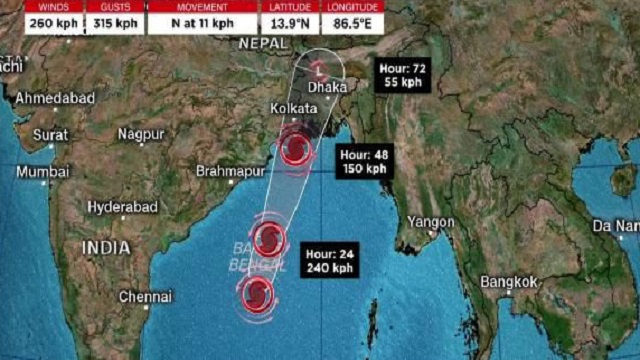
Live Correspondent: Amid a serious outbreak of the coronavirus pandemic, Bangladesh now braces for the strongest storm ever recorded in the Bay of Bengal.The Super Cyclone Amphan is intensifying with sustained wind speeds of up to 270 kilometers per hour, according to data from the US Joint Typhoon Warning Center.
The storm is a strong Category 4 Atlantic hurricane, or a super typhoon in the West Pacific having winds speeds up to 240 kph.This is the second super cyclone to hit the Bay of Bengal since records began. During the last super cyclone in 1999, nearly 15,000 villages were affected and almost 10,000 people were killed.
Amphan is likely to hit Bangladesh’s coastal areas on Wednesday evening, said State Minister for Disaster Management and Relief Dr Md Enamur Rahman.
Speaking at an online press briefing on Tuesday, he said the government has already taken all the necessary measures to tackle the intensifying cyclone that is likely to make landfall around 6am on Wednesday.
He said they will shift 20-22 lakh coastal people to the shelter centers by ensuring social distancing. The State Minister said people living in coastal regions of the country will be evacuated to safer shelters by Tuesday evening.
Enamur said a total of 12,078 shelter centres have been prepared in coastal areas where 51,90,144 people can be accommodated.
According to Met office’s latest bulletin, 5-10 feet high storm surge may hit the low-lying areas of the country’s coastal belt under the influence of ‘Amphan’ and the moon phase.
“Amphan is likely to move in a north-northeasterly direction and may cross Bangladesh coast between Khulna-Chattogram during late night of 19 May 2020 to afternoon/evening on Wednesday,” it s
‘Amphan’ over west central bay and adjoining area moved north-northeastwards and lies over the same area as an extremely severe cyclonic storm. It is likely to move in a north-northeasterly direction and may cross Bangladesh coast between Khulna and Chattogram either on Wednesday afternoon or evening, according to the Met office
Under the influence of the cyclone and the new moon phase, the low-lying areas of the coastal districts of Satkhira, Khulna, Bagerhat, Jhalakati, Pirojpur, Barguna, Patuakhali, Bhola, Barishal, Laxmipur, Chandpur, Noakhali, Feni, Chattogram and their offshore islands and chars are likely to be inundated by a storm surge of 5-10 feet height of above normal astronomical tide.
It centred at 03 pm on Tuesday about 785 km southwest off Chattogram port, 740 km southwest off Cox’s Bazar port, 670 km south-southwest off Mongla port and 665 km south-southwest off Payra port.
The maximum sustained wind speed within 85 kms of the cyclone centre is about 200 kph rising to 220 kph in gusts/squalls. The sea will remain very high near the super cyclone centre.
The maritime ports of Mongla and Payra have been advised to keep hoisted danger signal number seven. The coastal districts of Satkhira, Khulna, Bagerhat, Jhalakati, Pirojpur, Barguna, Patuakhali, Bhola, Barishal, Laxmipur, Chandpur and their offshore islands and chars will come under danger signal number seven.
The maritime ports of Chattogram and Cox’s Bazar have been advised to keep hoisted danger signal number six. Coastal districts of Noakhali, Feni, Chattogram and Cox’s Bazar their offshore islands while char areas will come under danger signal number six.
The coastal districts of Satkhira, Khulna, Bagerhat, Jhalakati, Pirojpur, Barguna, Patuakhali, Bhola, Barishal, Laxmipur, Chandpur, Noakhali, Feni, Chattogram and their offshore islands and chars are likely to experience a wind speed up to 140-160 kph in gusts/squalls with heavy to very heavy falls during the passage of the cyclone.
Dhaka, 19, May (campuslive24.com)//Ait
Topic:


Share Your Valuable Comments: